Over 3000 articles!
Cross stand Cross/ground stands are used on construction projects to establish reference points when adjacent buildings o...
View full detailsAdapter RSA-490M The RSA-490M adapter can be used when measuring near the roadside. Its magnetic base also allows it...
View full detailsAdapter RSA-5/8-1 with 5/8" thread With the RSA-5/8-1 adapter, prisms, laser scanner targets and drone targets from Rothbucher can now be easi...
View full detailsThe 90 degree angle adapter RSA-X80g-1 and/or the smooth adapter RSA-X80g-2 can be combined in several different ways See examples of use
Boundary markers RSKM10 to RSKM40 To ensure accurate measurement of boundary and measurement points on fixed surfaces within property bounda...
View full detailsLaser target The laser targets are designed for rapid positioning and use of the following instruments: Leica 3D Disto Geomax Zoom 3D ...
View full detailsLaser Target foldable for line laser Laser Target has been developed to quickly set a line laser in a precise position along the axis. Pla...
View full detailsLaser scanner sphere magnetic Laser scanner sphere with magnetic base / with suction cup Plastic scanning sphere with special matte textu...
View full detailsLaser scanner and drone sign, printed on both sides (gray-white / black-white), 400 x 400 mm, for long-distance scanning. When using mobile m...
View full detailsMini Prism With the RSMP10 and RSMP12 mini prisms, surveyors can now easily take measurements in cracks, holes and corners. Fixed dimensions g...
View full detailsReference line marking (RS95 and RS96) was developed specifically for setting out work on a hanger or on the floor plate. Accurate measurement of t...
View full detailsStainless steel metal adapter Bridge construction and bridge monitoring Tunnel construction Soil and rock monitoring – e.g. steeply uphi...
View full detailsGeoDist® 80 easily opens up even extensive outdoor areas with a homing camera. 4x zoom captures accurate measurements from long distances up to 80...
View full detailsHandle for Mesa Pro
Hand strap for Mesa Pro
Charging dock for Mesa Pro Batteries With the Mesa Pro multi-charger kit you can charge up to 2 batteries at the same time. This kit contains a...
View full detailsJuniper Mesa PRO Extremely robust design with a 10.1 inch screen and a battery life that lasts all day, regulates sunlight on the screen and is...
View full details3D High Performance Point Cloud Processing Whether airborne or mobile-collected LiDAR, 3D point clouds have become a critical element in mapping....
View full detailsThe TrueView® 655/660 is GeoCue's third generation RIEGL integration built with the miniVUX-3UAV and triple mapping cameras (right, left, nadir) f...
View full detailsTrueView 515 3D imaging system GeoCues TrueView 515 is simply the best performing mid-range LIDAR/camera system. This compact 3D imaging system f...
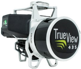
View full detailsTrueView 435 is the most economical platform for utility-grade mapping. GeoCue's TrueView 435 is our next-generation compact 3D imaging system that...
View full detailsSECO channel stick, aluminum Duct measuring rod with 2 prisms Length: 2m Weight: 1.7kg Offset -34mm
Specifically for the following DJI Drone controllers: M300, Cendence, Smart Controller and Phantom/Inspire controllers. Designed to provide com...
View full detailsSNLL321 sensor nadir laser plumb line For easy and quick centering on the ground with an accuracy of 1.0 mm at a height of 1.50 m. The built...
View full details